The purpose of this Program Guide is to provide direction for reading and understanding the Charlotte Future 2040 Community Area Plans (CAPs). The Program Guide document provides a brief overview of the Charlotte Future 2040 Comprehensive Plan and Policy Map and information about the CAP process, including what the plans are and how they were developed. This guide also provides information on other city- and county-wide policies that either support or are being executed alongside the CAP process.
This web version serves as a summary of the complete Program Guide, which can be viewed by following the link below.
Planning Tiers & Relationships
Charlotte has been one of the fastest-growing cities in the country, establishing it as a vibrant and desirable city, but also contributing to many challenges. The Comprehensive Plan represents a shared vision for the entire city to guide new growth and development over the next 20 years, providing a policy framework for decision-making and investment in both the near-term and long-term. The planning process for the Comprehensive Plan was guided by a focus on equitable growth and robust public input, resulting in 10 goals that reflect the voices of our community, articulate key elements of the growth strategy, and promote the concept of complete communities, where all residents can easily access daily needs, goods, services, and jobs within close proximity to their homes.
Adopted within the Comprehensive Plan is an approach and hierarchy for additional, supportive policy planning needed to implement Charlotte’s vision through aligned and coordinated efforts. The four planning levels are illustrated below.
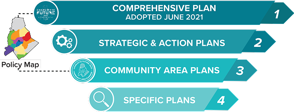
provides the highest policy level guidance for future development and redevelopment, infrastructure improvements and other public investments, transportation and land use connections, and other quality of life, affordability, equity, and sustainability factors.
build upon the Comprehensive Plan’s guidance to set more specific goals, objectives, policy direction, and specific projects for specialized topics across the city and/or county, such as for transportation, economic development, parks and recreation, housing, or natural resources and sustainability. Examples include the Strategic Mobility Plan and the Strategic Energy Action Plan.
provide detailed strategies and recommendations for land use, built form, transportation, infrastructure, parks, recreation, open space, and facilities for 14 sub-geographies across the city.
address smaller scale geographies and focus on implementation, such as transit station area plans, reinvestment plans, environmental impact action plans, or corridor plans. Examples include the Corridors of Opportunity Playbooks and GreenPrints.
The Charlotte Future 2040 Policy Map, as a companion to the Comprehensive Plan, is also an important tool that informs and is informed by the other planning hierarchy levels. The Policy Map translates place-based policies from the Comprehensive Plan to specific geographies across the city.