Creating Complete Communities
A key tool to advance East Middle & Outer’s priority goals and address its greatest needs, recommended Place Types from the Charlotte Future 2040 Policy Map delineate strategically organized patterns of development that encourage more integrated and complete communities. Read about each Place Type here.
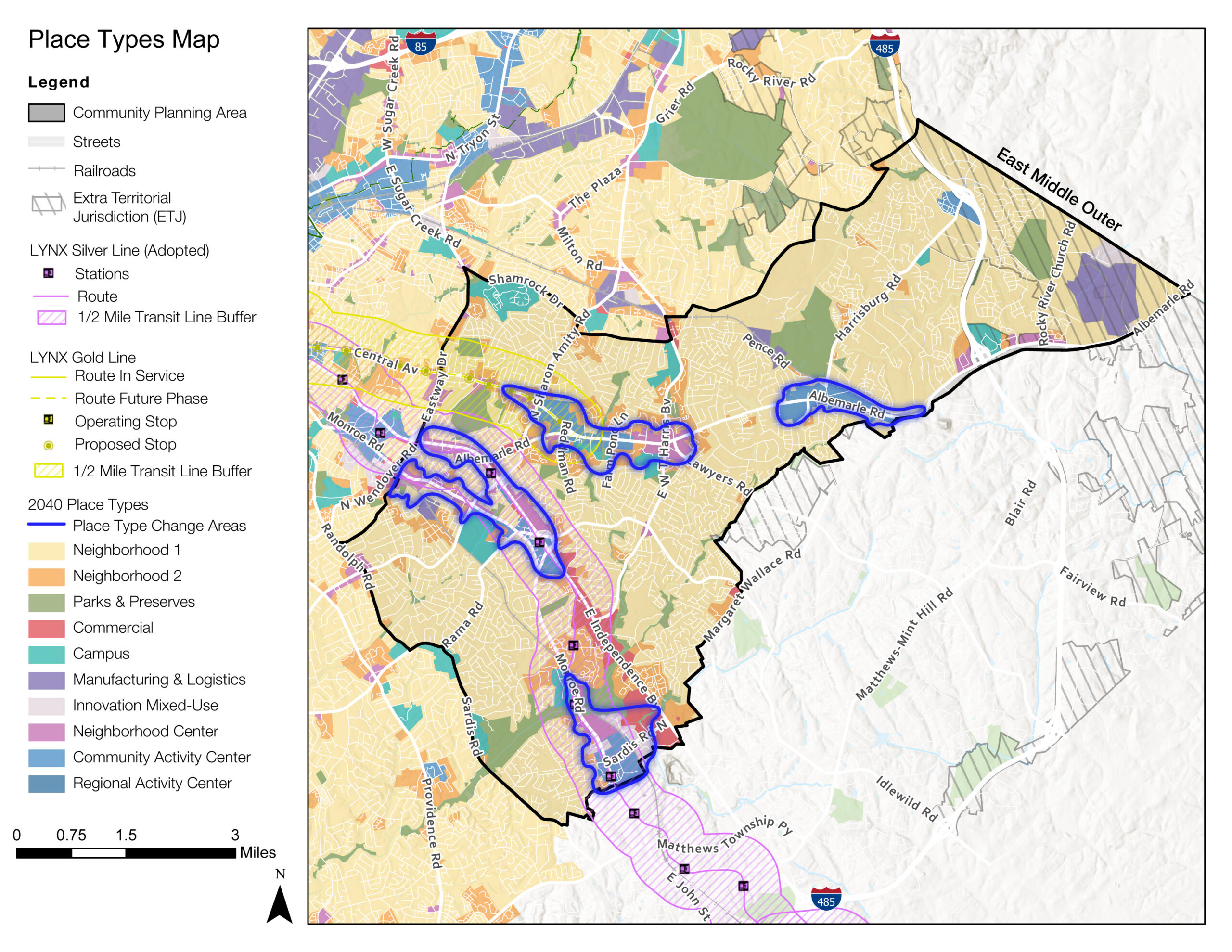
Map reflects designations approved by City Council at the adoption of the Community Area Plans.
Comparing existing development characteristics to the mapped future Place Types—which represent aspirational characteristics—illustrates spatially where most development growth and change is expected within this geography. There are four distinct types of Anticipated Change, each with a unique impact on increasing access and opportunity and reducing harmful impacts. The majority of the East Middle & Outer area is expected to maintain its existing characteristics – 82% – while the remaining 18% is recommended to evolve into a different Place Type than what exists today, with the aim to:
- Respect established neighborhoods
- Align with infrastructure capacity
- Create vibrant mixed-use centers that are accessible to all
The Existing to Recommended Place Types Chart below illustrates both the existing and recommended Place Type distribution for East Middle & Outer.
Anticipated Change reflects analysis conducted in March 2024.
Predominant Types of Change
About half of the East Middle & Outer areas recommended to evolve into a new Place Type are recommended as a mixed-use place (7%), which are expected to accommodate the vast majority of future growth across the city and will require the most intervention and investment to support their successful evolution. The Predominant Change Cards illustrate the four most predominant types of recommended change in the geography and how these types of change support the geography’s priority goals and greatest needs.


This change will add new residential development to the recommended areas and encourage specific civic uses to help create integrated and complete communities.
This change will add new residential development to the recommended areas and encourage specific civic uses to help create integrated and complete communities.


This change will add a greater mix of uses and density to the recommended areas, increasing access to housing choices, transit, jobs, healthcare, food, active lifestyles, and improved green infrastructure.

This change will add a greater mix of uses and density to the recommended areas, increasing access to housing choices, transit, jobs, healthcare, food, active lifestyles, and improved green infrastructure.
Creating Complete Communities Recommendations
PT-1
To ensure future growth helps achieve the City’s vision, encourage new development/redevelopment as recommended in the Charlotte Future 2040 Policy Map, which shows how the Charlotte Future 2040 Comprehensive Plan applies across the city and considers existing and planned infrastructure in guiding growth.
PT-2
To ensure successful implementation of the Charlotte Future 2040 Policy Map, approve entitlements through city-led or privately initiated rezonings that further the goals of the 2040 Comprehensive Plan and Community Area Plans.
PT-3
To ensure amendments to the Charlotte Future 2040 Policy Map are evaluated consistently, assess amendment requests based on the Minor and Major Map Amendment Criteria (see Table 3: Minor Map Amendment Criteria, Table 4: Major Map Amendment Criteria in the Program Guide), as well as goals of the Community Area Plan.
PT-4
When a zoning transition is needed because the recommended Place Types next to each other create a non preferred adjacency, refer to Table 2: Place Type Adjacencies & Zoning Districts in the Program Guide. This table explains when a zoning transition is appropriate. If a transition is required, choose the least intense zoning district that still aligns with the area’s designated Place Type.
PT-5
To ensure the scale and massing of new development/redevelopment is compatible with existing development, the following items should
be taken into consideration when considering a zoning change within Neighborhood 1 Zoning Districts. The listed items should not be
considered a comprehensive list of considerations and other contextual, locational, and site-specific elements may be considered when
evaluating the appropriateness of a zoning change within the N1 zoning districts.
- Existing lot pattern in the area of the request,
- Average lot sizes,
- Road frontage classification of the subject parcel(s),
- Location of the subject parcel(s); i.e.- mid-block, corner lot, etc.
PT-6
To ensure new development/redevelopment is consistent with the aspirations of mixed-use Place Types, the land use composition of Neighborhood Centers, Community Activity Centers, Regional Activity Centers, and Innovation Mixed-Use areas should be assessed at regular intervals, and the findings should be used in land-use-related decision making.
PT-7
To reduce residential displacement and promote housing choices, new development/redevelopment within the Vulnerability to Displacement Overlay (VDO) should consider incorporating mixed-income or senior housing.
PT-8
To help reduce displacement of existing small businesses, small business tools and resources are encouraged, where feasible, within Neighborhood Centers and Community Activity Centers located in the Vulnerability to Displacement Overlay (VDO), while recognizing that many tools and resources are not location-specific and are available citywide.
PT-9
To ensure delivery of adequate public services, consider utility capacity (water, sewer, and solid waste), road maintenance, emergency services, and evacuation routes when evaluating entitlements through city-led or privately initiated rezonings.
PT-10
To ensure future residential infill development is compatible with the character of existing neighborhoods, the City should adopt regulations that limit the maximum height of new homes to the average height of homes on the block (when permitted by state law).
PT-11
To respect the character of existing neighborhoods, the City should limit future development of triplex buildings to properties located along major thoroughfares (when permitted by state law).
PT-12
To encourage the development of new homes that are compatible with the character of existing neighborhoods, the City should establish an expedited permitting process for residential infill that meets guidelines for compatible development.
PT-13
To protect the character of existing neighborhoods, the City should create a voluntary program that allows property owners to place additional development restrictions on their own properties, such as limits on building height.
PT-14
To encourage land uses that maximize the benefits of transit, the City should review the Place Type designations of properties within a half-mile of planned rapid transit lines prior to completion of final transit design and construction.
PT-15
To ensure new development trends are compatible with existing neighborhoods, the City should establish guidance for new and emerging land uses, such as data centers, to ensure appropriate location and design.
Charlotte's Anti-Displacement Strategy
The Creating Complete Communities chapter provides guidance for how the plan area should evolve over time. Future development recommendations are intended to respect established neighborhoods, with areas designated Neighborhood 1 expected to remain in place. As the city grows and changes, some neighborhoods may be vulnerable to displacement. The City has identified anti-displacement as a key component of its long-term growth strategy and prioritizes efforts to support these communities.